At the moment Charlie and I are sitting in Panama City for the second of our two 5-hour breaks between flights. Gak! I guess it's faster than an old sailing ship - almost. We left Easter Island yesterday and will get to LA tonight at 5something or other. At least we found a comfortable lounge to hang around. I'll post my last few photos from Friday mornings walk.
Until then....
Saturday, August 17, 2013
Thursday, August 15, 2013
AUG 15 - OUR LAST TOUR DAY HERE.
We started our day with a new tour guide, Hugo. He's more experienced than the extremely young John, but a bit more ...... mystical. I'll explain later.
We had seen most of the major tourist sites on the island, so today was a brush up on details. Hugo, also a Rapa Nui native, was full of details.


We had seen most of the major tourist sites on the island, so today was a brush up on details. Hugo, also a Rapa Nui native, was full of details.

The platforms that had fallen Moai still contained the bones of the people that the Moai represented. The people in the north, near the quarry, were the builders of the Moai. The people of the south paid in various goods to have the Moai built. After a time, when it became apparent that the northerners were becoming Moai building slaves, they quit building them.

In the distance is a platform with a few topknots scattered about. All the Moai were broken, weathered, and buried.

It was cool and misty here today. Fallen Moai and a rainbow set the scene.

The statue above is supposed to be a Moai of a young boy. He was supposed to be able to heal people. People would come and he could help heal them. We're not sure how he achieved this.

Most of the platforms had crematorium next to them. The style of the platforms and the crematorium were different from tribe to tribe. Charlie and I originally thought there were only a few tribes. We were incorrect. There were apparently as many at 54 of them. Each group must have been very small. Each with their own platforms, Moai, and all. When the war broke out amongst the tribes, neighbor was literally fighting with neighbor.

The house in the photo above is in the style of the canoe house that the native Rapa Nui people constructed from stone and palm fronds.

The photo above is the local (near our hotel) boat dock. There is no wharf in town, and there isn't a port. Somehow ten or more cruise ships show up in the summer with more than 2000 people on each of them. People are let off the boats in groups of 400-500, they see very little, and are brought back to the boat. It takes two days to get everyone on board to see what little they can. Oil is brought to the island by a ship that has to be more-or-less dry docked to keep it from swinging around to much in the tide. Then divers attach pipes from under the water to a container on shore. It takes four days to empty the oil ship.
We went to a museum, but my camera ran out of battery power at the time, so no photos. It was interesting, though.

The photo above is another astronomical Moai. He is supposed to have been a great island astronomer. Hugo explained that on June 21st the sun is over his head for 10 minutes. I'm not entirely sure what he meant - the mysticism began.

The northern shore of Rapa Nui.

I'm standing next to a topknot. The curved surface was the portion that was stuck on top of the Moai's head, and balanced there.

Hugo's most interesting stories were about himself. He came from one of the northern tribes and was raised by his great-grandma. She build a stone house with a tar roof by herself (good grief). She made an attempt to sell it when she left, but it's been left standing. It is in a fishing area, and the local dock is seen in the photo above.

We've been seeing lots of petroglyphs but the octopus above is my favorite, and the easiest photo to see.

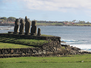
At the end of the day we went back to the 15 Moai that have been reconstructed. Horses were grazing all over the area. Since bones, belongings, and many other things are buried in the platforms, the horses hoofs tend to smash the stones, so Hugo chased them away.


To the right of the fallen Moai is the road that he was dragged on to get to a platform that was no more than 80 m from where we were standing. Hugo's guess is that once he toppled over, he was shoved to the side of the road. Months of work down the drain, and so close to the end of the road. Hugo told us how the scientists think the Moai were moved. The legend of the natives is that they "thought" them into place. hmmmmm - or better - sang them into place - I guess I'm just not mystical.
Tomorrow we begin our three flights home. We leave here around 1 PM Friday and get home 4:30 or so on Saturday.
Wednesday, August 14, 2013
AUG 14 - 2 1/2 DAY TOURS = 1 LONG DAY TOUR
Another great day on the island. We left for the tour at 9 AM, and first drove to a cave that was used by the Rapa Nui people. They could stay there for shelter, and use the calm entrance as a boat ramp. There were some cave drawings inside, but weather and my photos really didn't show much. The "paint" was ground red and black stone mixed with water and fish oil. They used coral for white.


Our next stop was a crater view of Rano Kau. This one like the other we saw is full of water. Apparently when the British came around 1850 they brought the natives clothes. The only place to wash their new clothes was the bottom of this crater. You could see a little trail leading down the sides of the crater to the water. The greenery in there is a type of reed.


John told us the local people like to swim in these areas since the tourists like to hang around the white sandy beaches. This way the locals get some privacy.

During the late 1600's and early 1700's some locals mostly due to starvation fell to cannibalism. Those that did were sent to this cave. Not much of a way out of there.
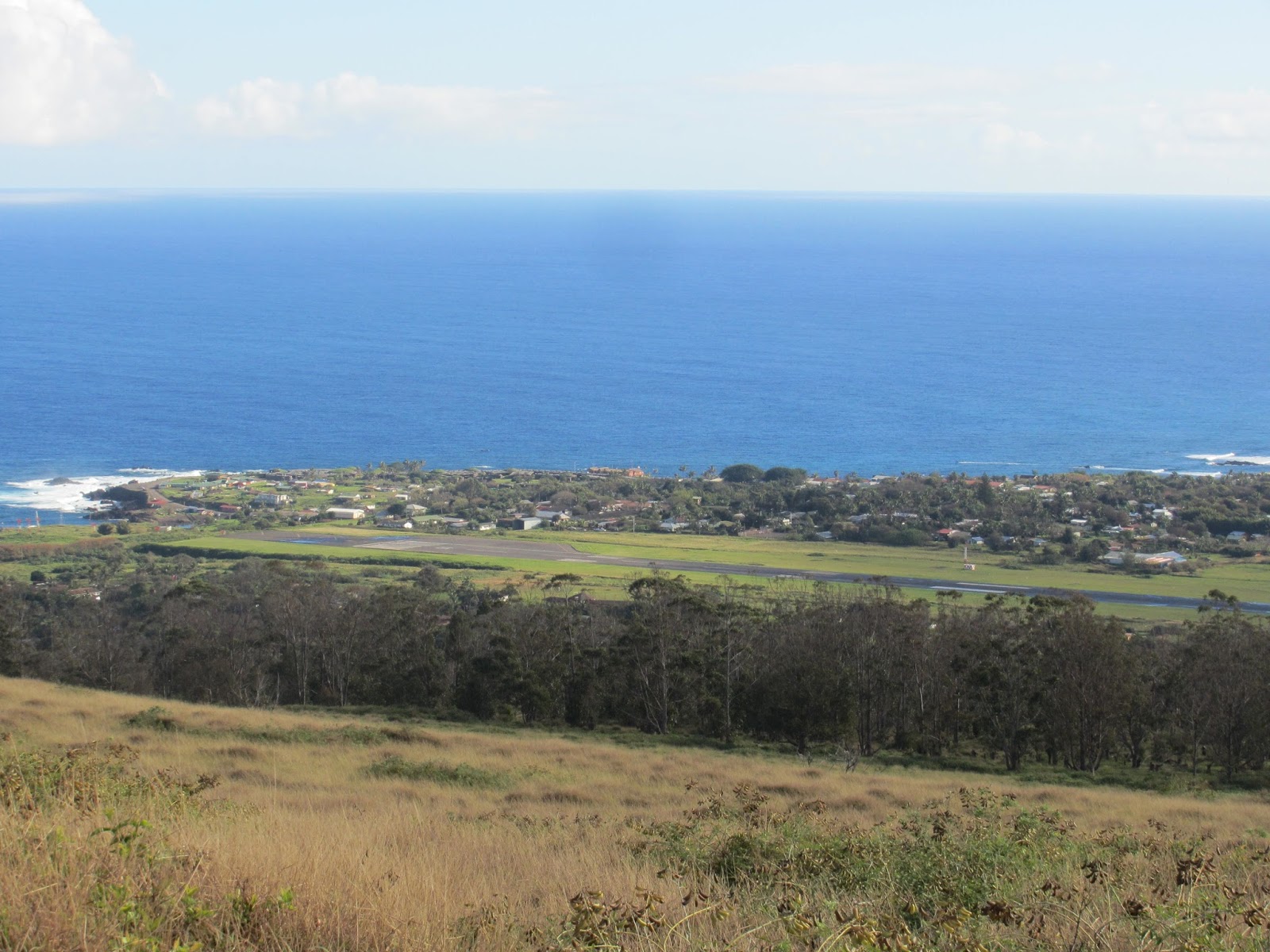
We stopped for a beautiful overlook. The town of Hanga Roa is in the distance. In between the trees and the town you can see the air strip that we landed on. One plane comes in each day. Monday there are two planes, one of which goes on to Tahiti. The strip was originally built by NASA as a back up landing strip in the middle of the South Pacific for the shuttle program.
When the British came to the island they brought sheep, eucalyptus trees, and fenced all the islanders into the Hanga Roa area. The sheep, British, and the fence are now gone.


Us at the crater.
Today's big history lesson was the story of the Birdman Competition. After years of fighting amongst themselves - Moai tipping, murder, and the like - a king had a brilliant idea. He decided to eliminate the Moai ancestor worship and to bring in a competition. The Petrogliff below shows a birdman depiction. Bird's head to the right (beak upwards) man's arms upward and legs to the left.

For centuries in the spring around here (September) Sooty Terns would land on the largest of the little islets in the photo below. Seven clans would come to Orongo (site of the competition) and wait for a birds to land on the islet. When the birds would take off for food, the competition was on...


Us at Orongo

Housing for the contestants and their entourage. A chief, a priest, and two other warriors who came along, just in case.

The contestants and to first climb down the cliff face that was a wall of the volcano. They then had to swim to the islet, find a tern egg, stick it on a headdress so he could swim back to shore. The swim is about 1400 m, but they did have reed floaters to help them. The first person to do all of this became leader of all the clans for a year. The head birdman.
We then went back to the hotel, had a great lunch, then hit the road around 2:30. Our first stop was Puna Pau. It is a quarry for the red, volcanic tuff (a welded volcanic ash) that was used for the topknots on the Moai's.

Above is an abandoned topknot.

The Puno Kau quarry.
Our next stop was Ahu Akivi. These Moai were different in several ways from the Moai we'd seen at the coasts. First of all there were seven of them sitting about in the middle of the island. They were roughly the same size, and the platform that they sat on was not filled with bones - it was purely a platform. On the day of the Fall equinox (March 21st around here) the sun rises above the middle of the seven Moai.


The equinox Moai.
Our next stop were the Lava Tube caves at Ana Te Pahi.
John next to the sign for the caves. We had just ridden across what must have been the worst road I've ever been on. Pools of water, enormous ruts and holes, and stones of all sorts and sizes blocked the road. Good grief.
Below are a few photos from inside the cave.


We went in and out of one cave, then John asked us if we wanted to have an adventure. He said he had a flashlight. We ended up walking about 200 m in the cave - only a flashlight to see where we were going, and scrambling over damp rocks, made it a real adventure. The only places where we had to crouch was getting out of the cave at the end. I'm real brave if I can stand up in a cave.
Our last stop was Tahai, the place Charlie and I had walked to our first day out. The photo below show the Moai and in the distance behind them, is our hotel.

One more touring day - until tomorrow.
Tuesday, August 13, 2013
AUGUST 13 - A FULL TOUR DAY
After breakfast this morning we were picked up at the hotel by John, our guide for the day. He is 100% Rapa Nui (it means "big island" in the native language). The population of the island has about 1000 pure islanders, 3000 mixed people, and about 2000 people who rent homes here. Apparently, you can't buy property on Easter Island. We asked John if his could understand other Polynesian people. The easiest for the Rapa Nui folks to understand were the Maori from New Zealand. Then the Tahitians (they could understand about 50% of what they said.) The Hawaiians were really difficult to understand (only about 10%) because the Hawaiians introduced the "L" sound which isn't in the other Polynesian dialects.
Our first stop was Rano Raraku. It was the quarry for the Moai for the island. They were carved here then dragged (many different theories as to how they managed to do this) to various sites around the island. The Moai below (behind us) were in the process of being excavated and were never transported for various reasons.


In the afternoon we went to Te Pito Kura. It was the site of another platform and collapsed Moai. In the distance you can see the edge of the oldest volcano on the island. There are three main volcanos that make up Easter Island. The other thing that was here was a round stone which had more iron than the average stones and was magnetic. Apparently, it was a very popular and mystic thing to sit and feel the magnetic vibes. Good grief.

Our last stop was Anakena. One of the two sandy beaches on Easter Island. The sand was amazing white, ground-up coral.


Our first stop was Rano Raraku. It was the quarry for the Moai for the island. They were carved here then dragged (many different theories as to how they managed to do this) to various sites around the island. The Moai below (behind us) were in the process of being excavated and were never transported for various reasons.

The largest of the Moai are 23 meters. They have bottoms as well as tops, most of each statue is left underground to help preserve them.

There are two Moai in the photo above - one was in the process of being carved out of the rock when the carvers gave up.

Another view of the fallen and rejected Moai.
The Easter Islanders, after a very auspicious beginning, broke into 15 clans who then began to fight one against the other. The ultimate result of the civil war amongst the clans was they toppled over the Moai from each clan. The ones that are upright today have been re-set up to see what they looked like before the battles.

The Moai above is the only one who's in a kneeling position. The archeologists who uprighted the Moai decided to leave the bottom parts of them underground to keep them preserved. The weather, lichens, and all does real damage to them.
We then went up to the crater of the Rano Raraku volcano. There was a lake in it. The reeds around the lake which float on it are the only naturally occurring plant left on the island.

John and Charlie sitting near the lake. John told us about a native tri-athelon in this crater. 1st a canoe race across the water, 2nd carting 2 twenty kilo stones running around the lake, and 3rd ran up inside the caldera grabbed a paddle board and swam across the lake.
We then went to Ahu Tangariki (Ahu means platform - it's the stone platform that the Moai were meant to sit on)

John is showing Charlie the remains of the Rapa Nui house structures. Basically the size and shape of the canoes that brought them to the island - the roof looked like overturned canoes covered in grass. They were only used for sleeping.

The quarry from Ahu Tangariki

Charlie and John near a collapsed Moai - 15 standing Moai in the rear. The Moais actual direction was always away from the coast facing the people who lived near them - they eyes facing the stars

The 15 Moai behind us represent each of the 15 clans. An attempt at peace which apparently didn't work. These Moai were knocked over a 2nd time in a tsunami which occurred after the 1960 Chilean earthquake.

Next on our tour Aka Hanga. This was a site of a platform that was in the "original" condition after the warring clans got done knocking over each others Moai. In the platforms under each of the Moai are the bones of the person for whom the Moai was constructed. Apparently the bones have been taken from the platforms that have been reconstructed. The one below still has the bones remaining in it.

The site for the platforms had to have several basics: 1.) an inlet so they could get out and fish 2.) a raised hillside 3.) water and 4.) a cave - like the lava cave below - which was used for (among other things) a birthing chamber.


The inlet (and view) from Aka Hanga

Our last stop was Anakena. One of the two sandy beaches on Easter Island. The sand was amazing white, ground-up coral.

Souvenir stands and snack shops near the parking lot.

These Moai in the foreground were very well preserved. The thinking goes that they had been buried in the lovely sand and that kept them in great shape. The Moai in the background was uprighted by Thor Hyerdahl.

Charlie on the beach. We both went into the water. As John said, "It's fresh" AKA brrrrrrr.
Subscribe to:
Posts (Atom)