We decided to drive to Hilo using the saddle road which runs between Mauna Loa and Mauna Kea. The weather in Kona was a bit iffy, so we decided if the road seemed clear we'd try it. Fortunately, it was gorgeous!
Driving out of Kona there were a couple of gas stations, which we drove past. Charlie was sure there'd be more. No. So we went back to Waimea (a 20 minute detour), got gas and got on the saddle road.


The trip back down was fascinating. Part of the road had an incline of 17%. If you look carefully at the photo below, you can see the saddle road hiding in the darker green.


Driving out of Kona there were a couple of gas stations, which we drove past. Charlie was sure there'd be more. No. So we went back to Waimea (a 20 minute detour), got gas and got on the saddle road.

You can see Waimea nestled at the base of the hill to the far right.

A view of Mauna Kea from the belt highway.

A closer look at Waimea

On the road toward Mauna Kea. Cinder cone in the foreground

Better view of the cinder cone.
Mauna Loa from the saddle road. Both huge volcanoes had snow on top.

View of the saddle road.

We took a side trip up to the Keck Observatory. The building shown here is the information center. It's located at about 8500 feet in altitude, and we couldn't go any higher without a four wheel drive vehicle. Our poor little rental car wasn't too happy with 8500 feet. The Mauna Kea peak is about 13,796 feet. Mauna Loa is about 13, 250 feet.
The photos below are of Charlie and me near the information center.


This is a Silver Sword. It grows on the upper slopes of Mauna Kea.
The trip back down was fascinating. Part of the road had an incline of 17%. If you look carefully at the photo below, you can see the saddle road hiding in the darker green.


Mauna Loa from the saddle road.
In Hilo we went to the Wailoa River State Park for lunch. Trying to find a toilet, we wandered into the Wailoa Center. An interesting building that puts on exhibitions. This one focused on art works made from Hawaiian wood. What a great and beautiful find!


View of Mauna Kea from the park in Hilo. I'd been to Hilo three times and never knew you could see the volcano from here because if was always too cloudy.

Nifty bird on the lawn near the Waimea building
We took a four mile scenic drive after lunch.

A view of Hilo from the scenic road.

Some of what made the scenic road scenic.

At the end of the scenic road was another wonderful old-Hawaiian town. Pepe'ekeo


Akaka falls. It was beginning to really cloud over so our photos became less spectacular. The falls are in a state park, and the rangers had knocked down several trees which had blocked half the path to the falls. We could only walk one way and return the same way. When we asked why, the told us the trees weren't indigenous and falling branches made them dangerous. Apparently so. The tree falls themselves did a great deal of damage to the trail.

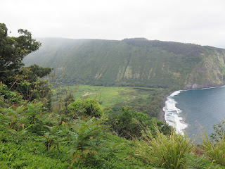
Our final stop was Wailoa Valley. The clouds were beginning to really coming in, and it was beginning to rain. We could still get a shot of the valley from the rim, but any thoughts of hiking down to it evaporated. The Wailoa Valley was apparently very special to the Hawaiian kings.

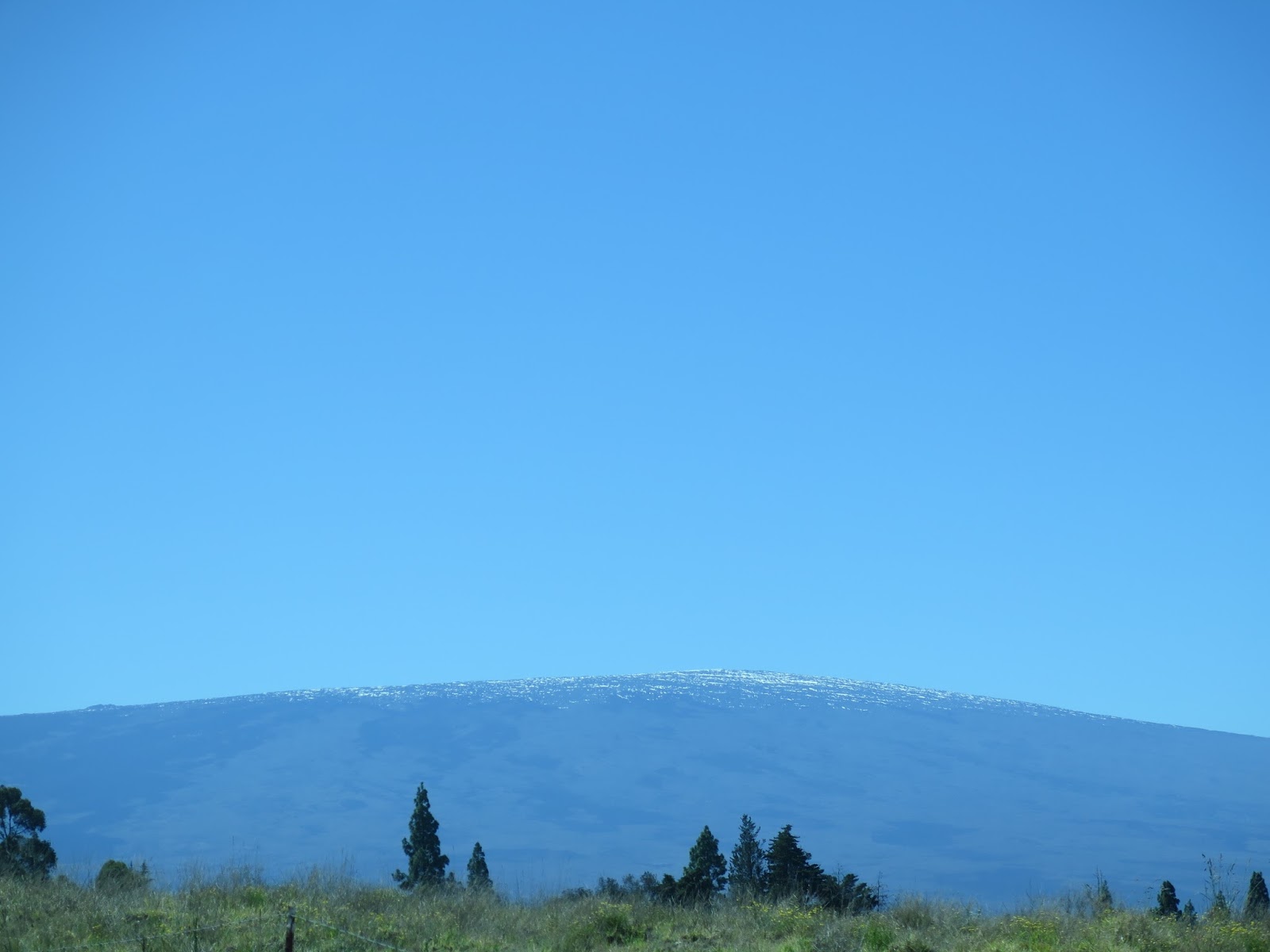
The photo above was taken from the airplane flying out of Kona back to LAX. My favorite view on the big island, Mauna Kea covered in snow.
No comments:
Post a Comment